|
55 days on the wallaby – an unauthorized guide to the Bibbulmun Track
In October and November 2008, three of us walked the 966 km length of the Bibbulmun Track, from Albany to Perth. These notes are for people who may be considering a similar venture, particularly if they are not familiar with conditions in Western Australia. They are intended to supplement the information available from the Bibbulmun Track Foundation and the Department of Environment and Conservation (DEC). If you are considering doing the walk, you should order from the Foundation:
It isn’t as hard as it sounds A 966 km walk may appear to be difficult, but don’t be put off.
It is made easy by:
a well-marked trail: there are trail markers all along the way, at every junction (and there are many junctions) and every few hundred meters along the way (be warned, however, that there are many other trails crossing the Bibbulmun, and these have their own markers, some of which may bear a superficial resemblance to the Bibbulmun markers). You should be able to do the walk without a compass or GPS (but you should carry and use the DEC maps and guidebooks).
You will find some people referring to the trail markers as “Wauguls” – a Nyoongar term which doesn’t translate to “trail marker” or anything similar (the Nyoongar people had other means of navigation). Rather, the word refers to the Rainbow Serpent, which is presented in a stylized form on the Bibbulmun trail markers.
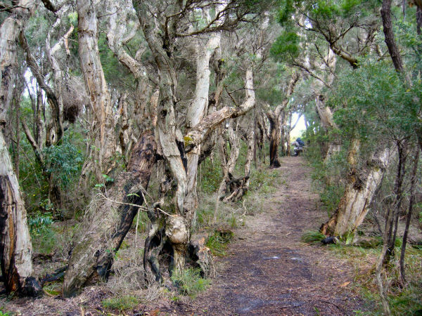
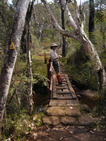
a well-graded trail: there’s no bush bashing, and only a little scrambling over rocks. Elevations are modest; while the country is generally undulating, only very few climbs exceed 200 meters. In the north, along the Darling Range, the surface is a reasonably solid laterite, often overlaid with pea gravel which makes for an easy surface. In the south the track is more sandy, but generally firm. Many tracks are on well-graded old railroad easements, and, apart from one low-lying section near the coast, you need never get your feet wet. (Bridges are one of the features of the track.) There is only a handful of short sections which could be described as difficult. (See below.)
campsites: a modest term to describe what are really five star facilities. Each “campsite” has a shelter open to one side (like an oversized bus shelter) with a sleeping platform, a rainwater tank fed from the roof, and a toilet (usually a pit toilet, and often with toilet paper provided). The shelters won’t keep you warm, but they will keep you out of the sun, rain and wind. They vary in size depending on the popularity of the region concerned. Only one campsite, Mount Wells, is not specifically designed for walkers; it is a rather dingy and pokey old towerman’s hut, which certainly makes one appreciate the quality of the other 47 shelters.
We were pleasantly surprised to find that at our ages (58, 62, 63) we were by no means considered “old” among track users. We came across several people in their seventies, and found a few log book entries made by people in their eighties. It was tough to start, partly because we weren’t at our peak of fitness (to put it mildly), and because we were carrying 13 days of food for the first leg from Kalamunda to Dwellingup, which is by far the longest leg without a town. But within a few days we were finding it easy as our bodies got used to it, and we soon started to lose excess body weight. There were a few blisters in the first week, but from then on our feet and boots established a harmonious relationship.
A quaint piece of local argot is the constructed verb “to double hut”. It refers to the practice of walking two sections in one day. At the very end we came across one person, aged 22, who had completed the whole track in 18 days, and we came across another who overtook us on the way south and who passed us on his way back from Albany, on a 1932 km return trip.
The bits we found a little difficult are:
Dookanelly to Possum Springs (Section 20). This has four or five very steep hills, each about 80 meters climb. For us, the real challenge was not so much climbing them as going down the other side. There is also a very steep descent, of about 130 meters, on the approach to Balingup (Section 27).
From just north of Northcliffe to the Woolbales campsite (Sections 38 to 43). When we walked this section, in early November, there was still a fair bit of water in the low-lying parts, particularly in what is known as the Pingerup Swamp. There are some duckboards, and in many places people have made side tracks (causing an amount of environmental damage along the way), but in others – perhaps 500 meters when we add it all up – there was no option but to wade. Don't be put off this section however; it is one of the more unusual landforms, and it has a huge variety of vegetation.
Boat Harbour to William Bay (Section 52), and Torbay to Hidden Valley (Section 57). Each of these sections involves a crossing of an inlet and a beach walk of about 7 km. Depending on the time of year, the inlets may be “open” (i.e. deep creeks running across the beach) or “closed” (i.e. sandbars have developed “closing” the creeks). We found these inlets to be “open”, which meant we had to wade, with water almost a meter deep at the narrow channels. We were well-guided by the instructions on inlet crossings in the guidebook, and by the experiences of people coming in the opposite direction. There is some official information on inlets provided by the DEC, but it is not possible for them to keep it up to date, for conditions can change very quickly. The beach walks had some soft sections which made progress slow and difficult; we found about two thirds of Mazzoletti Beach to be soft, while almost all of Perkins Beach was firm, but these conditions can change quickly. (Remember that sand tends to be firmer if it is cool or moist.) We didn’t even attempt to cross Wilson Inlet (south of Denmark) or Irwin Inlet between
Peaceful Bay and Boat Harbour (Section 51), where we used the canoes. But we understand
there are times when these inlets are “closed”.
There were few hazards:
Yobbos – particularly around Collie, there were sections of the track which had been churned up by motorcyclists. Late one evening we were awoken by pig shooters who had driven in their Land Cruiser equipped with spotlights, pig dogs, and six packs. In one place (near Harris Dam Campsite) a locked gates restricting vehicle access had been vandalized, and it looked like DEC had long since given up trying to repair it.
Wildlife – there are ticks along the way, but locals seem to be more nonchalant about them than we are in the eastern states. In our walk, two of the three of us got one tick bite each, and they were easily removed. There are mosquitoes, which carry the risk of Ross River Virus, and there are snakes – we all saw several Tiger Snakes. These hazards are described well in the guidebooks. One aggressive animal not listed is a large biting ant, which can deliver an intensely painful sting and a few days of local swelling. One can take comfort from knowing that there is no record of snakebite on the track, that the track is generally close to main roads, and often has cellphone contact.
Other campers – by and large people are well-behaved and considerate. In the first sections, however, there was a little loutish behavior by young men (never among mixed gender groups – why are so many school groups all male?). And there was some inconsiderate behavior – people scattering their gear throughout the shelters, decorating the inside with wet socks and underpants (having used scarce tank water to wash their clothes), and building large campfires for no apparent purpose (perhaps those who build fires should be required to buy carbon credits). At one campsite (Harris Dam) a teacher drove a bus with a load of school children right into the campsite (fortunately they were well-behaved); he obviously considered the vandalized gate as authority to drive right up to the campsite. But these few negative experiences should not deter anyone. They detracted only slightly from our enjoyment. You will be able to avoid crowds if you avoid school holidays, if you try to be clear of the parts near Perth and Albany at weekends, and if you look up the DEC website for registrations of large groups.
Stuff that isn’t in the guidebooks
Fruit restrictions – if you are coming to WA by plane or car, there are fruit inspectors, who take a tough line on all fruit (fresh or home dehydrated) and honey. The checkpoints on the Eyre and Victoria Highways look like they have been imported from the East German border, being surplus to requirements following reunification, but the staff are friendlier than the Stasi and they aren't armed. You can confirm the quarantine rules at the Department of Agriculture and Food website.
Shopping hours – in Western Australia you can re-create the experience of Australian country towns in the 1950s. Retailers and the state government are gripped by a fear that if shopping hours are deregulated people will spend more money and stimulate the economy. Many shops, even big supermarkets, close at 5 or 6 pm. Pubs stay open longer, but if you haven’t ordered food by about 7.30 pm in a pub or restaurant, you are likely to go hungry. The Accommodation and Services Guide, and signs outside shops and cafes, list opening hours, but these are loose; many establishments close in the early afternoon. (There’s a fairly casual business attitude in the region.) When we went through, the North Bannister Roadhouse (Section 12, near Gringer Creek campsite) had only just re-opened after refurbishment. The Mumballup Tavern (Section 25) and the Graphite Café (Section 32) were both closed, and looked like staying that way for some time.
Food availability – you will find well-stocked supermarkets in towns along the way (the exceptions are Donnelly River Village and Peaceful Bay, both of which have only basic food shopping) but there is very little specialist food for walkers. There is a camping shop in Collie, but it is mainly about hunting, shooting and fishing (they have enough ammunition to start a civil war). The Collie camping shop was the only place where there was Back Country dehydrated food, but their stock was very limited.
Fuel – it was easy to find gas and methylated spirits. Note that fires are prohibited from Mount Chance southwards, and during fire ban seasons.
Internet access – there was no internet access in Dwellingup, Collie or Balingup. The Internet Café in Collie was closed, and, contrary to the advice in the Accommodation and Services Guide, the Post Office in Balingup provided internet access only to those who stayed at the associated accommodation. Further south, however, there were many internet cafes etc with very reasonable fees.
Visitors’ centers – these are excellent sources of advice and help – often staffed by local volunteers. If you have to catch buses (as we did to relocate our car), you will need to do so through the visitors’ centers, where they will make reservations and issue tickets. It’s a quaint paper-based system, reminiscent if the 1950s, but it works.
Pubs – Western Australia has no poker machines in the pubs (called "taverns" if they do not have accommodation). That makes them much more civilized places than those you come across east of Longitude 129 degrees. Many restaurants were closed on Monday nights, and the pubs tended to specialize in roast dinners on Sunday nights (remember that WA has a large share of Australia’s British immigrants).
Wines – a well-kept secret. Everyone knows about the Margaret River wine region, but the wine region of Western Australia is much larger. There were excellent local wines in most towns. Donnelly River and Peaceful Bay were dry.
Radio coverage – there is good ABC coverage near Perth, and from Walpole to Albany. Otherwise you will be in the dark – as we were about the US election and the financial crisis (particularly annoying when we couldn’t get internet access), and we couldn’t get weather forecasts. The towns have newspapers, but you will be lucky to get an Australian. Otherwise your choice will be the West Australian (right wing and parochial), numerous soft core porn magazines, magazines about cars, boats etc, a British paper called The Express (full of news about UK football) and, of course, the Women’s Weekly. There was welcome relief at the IGA supermarket in Dwellingup and Cohen’s Newsagency in Collie, both of which stocked the Guardian Weekly. Magazines like The Atlantic and Harpers seem to be unknown outside Perth.
Cellphone coverage – the higher ground in the northern section generally had good coverage. (It was possible to male calls from some hilltops.) There is no cellphone coverage in Balingup or Peaceful Bay.
Bibbulmun Track Foundation discounts – although the Accommodation and Services Guide lists many establishments offering BTF discounts, few have heard of such arrangements.
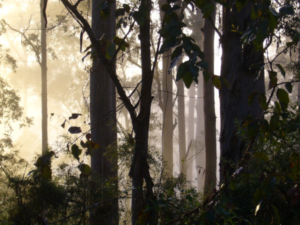
Weather – you will find good climate data on the Bureau of Meteorology website.for Kalamunda, Dwellingup, Pemberton, Denmark River and Albany. But averages can be misleading. We struck an unusually cold October in the north and an unusually wet November in the south. We also met an experienced outdoor teacher who told us that most (75 percent) rain in the region falls at night – a claim which turned out to be accurate. In the south in particular the humidity was very high (hardly any difference between the wet and dry bulb temperatures), and as it cooled in the early evening the rains came. Also, wherever we were, there were land breeze/sea breeze effects; sometimes a cloudy day would be followed by a clear, cold night, with temperatures which felt to be down in the single digits. Although it was generally warm walking, the nights were often cold.
Water – every campsite has a tank. At only one campsite was the tank less than half full (it may be a different story in summer). There is advice on the tanks warning people to boil or purify the water, but we didn’t bother and suffered no consequences. There are many streams and rivers along the way, but most of the larger streams rise in agricultural and other settled areas and are therefore not safe to drink. We found a range of accommodation along the way. The most convenient accommodation for our small group was in self-contained cabins, often in the trailer parks (called “caravan” parks in WA). In Collie we stayed at the Whispering Pines, which was truly delightful. In Balingup we stayed at the Balinga Cottages, also an excellent venue which we would recommend to others. One establishment not listed in the Accommodation and Services Guide is Nutkin Lodge, on Section 49 between Giants and Rame Head campsites. Giants was still not re-built following tree damage, so we moved on to Nutkin Lodge, which is about 300 meters off the track just south of Nut Lookout (Section 49). It provided a spot of luxury on what turned out to be a very wet night. There were a few establishments described as “backpackers’” accommodation. The term “backpackers” is somewhat misleading, for these establishments are really for low budget travellers and seasonal workers, rather than for real backpackers who seek a spot of comfort after carrying a backpack for several days. They may offer value for money, but they were certainly not what we were seeking.
Useful (or gratuitous) advice
Tent – to take one or not. In our two months on the track, which was during a reasonably busy period, there was only one night when the shelter could have been considered to be crowded. (Often a shelter will look crowded because people get too much spread on their gear.) It is wise, however, to carry a basic emergency shelter.
Maps – we bought the maps and guides, but the DEC maps are big and fragile. We copied a map of each day’s walk on to a piece of A4 paper (noting features from the guide books), which we were able to carry in a pocket and discard at the end of each day. To get an overall impression of the walk there is a good HEMA map South West Western Australia. There are also the Natmap 1:250 000 maps which give a broad view. The 1:50 000 DEC Bibbulmun maps are very accurate, but they are scarce on some physical detail, and, annoyingly, the roads and contours are in almost the same color.
Quick dry clothes – recommended.
Etiquette – be considerate of others, particularly at campsites. The campsites are exquisitely located, often with orientations that would win architectural design awards because of their views. Don’t spoil it by spreading your gear around or by hanging your wet laundry all over the shelters – there are more aesthetically pleasing vistas than your wet socks and underpants. In any event, the air is so damp most of the time that they won’t dry anyway.
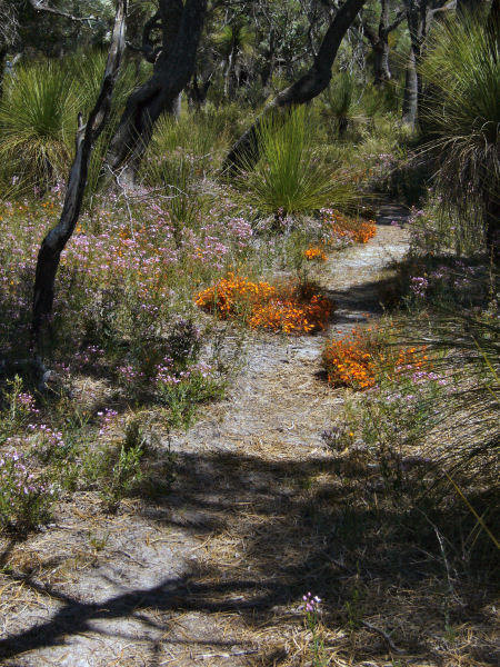
Bush books and other guides – can add to enjoyment and appreciation of this unique area. Remember that the region is one of the world's biodiversity "hotspots". In the 60 million years since it has wandered north from near the south pole it has never been subject to the destructive power of glaciation, which means plants have had plenty of time to evolve into their own specialized niches. There are some 80 000 plant species in the region, 40 000 of which are endemic. DEC publishes a series of small, lightweight (70 gram) Bush books, on geology, trees, flowers, fungi etc. No paper-based publication of course can do justice to this complex natural environment. Another guidebook, by Anne Ireland and Kim Macey, listing several hundred plant species, is Wildflowers of the Northern Bibbulmun Track & Jarrah Forests (published by the Bibbulmun Track Foundation). It is a modest 150 grams.
GPS coordinates – not really needed, but we plotted all the coordinates of our overnight campsites and town stays. They are in an Excel file. It's hard to get lost on the Bibbulmun, but you can if you try hard enough. And even if you're not lost, knowing the coordinates of the next campsite or town allows for a quick response to the question "are we there yet?"
|